

Otherworldly Landscape of Salar de Atacama
At more than 2,670 miles long, Chile may be the most geographically diverse nation in the Western Hemisphere. Based on the chatters online, the most popular region of Chile is Patagonia, with Torres del Paine National Park being the main draw. However, for me, the Atacama region in the northern part of the country is far more iconic and otherworldly. As soon as I saw the pictures of Piedras Roja, I knew I must prioritize visiting the Atacama region over Easter Island or Patagonia. Although the Atacama encompasses a large area, most interest points are situated within Salar de Atacama, the salt flat of Atacama.

A herd of vicuña along the Route 23.

The trek toward Piedras Rojas.
Like all visitors, we had our home base at the oasis town of San Pedro de Atacama. The town center has numerous tour offices selling dazzling options for day tours. Unsurprisingly, the majority of options are for sites within Salar de Atacama. Prioritizing is quite challenging. For various reasons, I did not do much research before this trip, so I only got to read up on all these sites a few days out. Since we already had a rental car, I was excited to check out many of these places at our own pace. However, it did not take me long to realize how difficult it is to travel independently in this region.

The melancholy of Laguna Tebinquiche.
First of all, it wasn't easy to figure out the opening times of these sites. I often could not tell whether the websites listed on Google Maps were official or fan pages. Many have conflicting opening times or no information on the ticketing scheme. Some sites have noted that access is only by prior reservation but have omitted the necessary instructions. Each site requires separate tickets/reservations on individual reservation systems and often requires registration on different platforms. I can’t help feeling that they conspire with local tour operators to make independent travel as difficult as possible.
Laguna Cejar & Laguna Piedra
Among all the sites within Salar de Atacama, the closest to town is Laguna Cejar. Accessible through a well-maintained dirt track, Laguna Cejar is particularly popular because one of the lakes is open for swimming. The reservation website was relatively straightforward, but the reservations were only open for the first two hours of the morning. The afternoon time slots, preferable due to better light, were reserved exclusively for organized tour groups. It confirms my suspicion that independent travelers are at the bottom of the totem pole.

Many visitors who showed up without reservation were turned away.

The state-of-the-art shower and changing room facility.

The trail to Laguna Cejar.
After entering with our QR code, I quickly noticed a long line of passengers’ cars idling by the gate. All these unprepared travelers showed up without a reservation and were told to purchase the tickets online on the spot using the non-existent cell signal. I fully understand and appreciate the need to control the number of visitors, but I was still taken aback by the absence of rigidity in their ticketing system. If there is spare capacity for the hour, why wouldn’t they let people pay by cash or credit card on the spot?
Like other sites in the region, the local community collectively owns and administers this place. At $15,000 CLP a person, Laguna Cejar may be expensive, but we got what we paid for. From the immaculate boardwalk to the beautiful bathrooms, the facilities here are even better than at the Explora-operated Termas de Puritama. Laguna Ceja is composed of three separate pools. The first pool is the largest of the three and is filled with wildlife, including half a dozen Andean flamingos. They are surprisingly unbothered by spectators. We were surprised we could observe them in such close range.

A close encounter with wild Andean flamingos.

The crystal clear water of Laguna Piedra.
For most of us, the actual draw is the second pool: Laguna Piedra. The pool's hypersaline water is among the saltiest in the natural world. A staff member quickly recites the rules, including the maximum time allowed in the water and not to submerge heads below the water. The water is at a refreshing temperature of 68 °F, which could be a welcomed respite in the midday sun. This was our first time floating in a saline lagoon, so we did not know what to expect. I had been worried about a few minor cut wounds, so I was a little hesitant to get into the pool. I was also concerned I might be too heavy to float. That would have been super embarrassing.

Laguna Cejar.

Floating in Laguna Piedra.

The crystal clear water of Laguna Piedra.
Fortunately, none of my worries were taken care of. The sensation of floating effortlessly is hard to describe. It might feel relaxing at first, but we were overly conscious of the potential danger of hyper-saline water. Most experts recommend limiting the immersion to twenty minutes to prevent excessive dehydration. The salty water could also mess with the body’s electrolyte balance and may cause fatigue in a short period. Together with intense UV rays, we dared not float around too long without a watch or clock nearby. Because of the strict crowd control, the pool never felt crowded. I am glad they did not ruin the natural ambiance here with tacky lounge chairs.

Laguna Piedra is undoubtedly the main draw.
Given the ongoing conflict between Israel and Palestine, I knew it was unlikely that we would be able to float in the Dead Sea anytime soon. From all the videos I watched about floating in the Dead Sea, I could tell that Laguna Piedra is a far more serene and sublime experience. The views of the volcanos in the background were spectacular. We would have loved to be here around sunset, but I don’t believe I would pay to join an organized tour just for that. With a bit of planning, visiting Laguna Cejar independently was certainly doable.
Ojos del Salar & Laguna Tebinquiche
From Laguna Cejar, it was only a quick drive to the next stop: Laguna Tebinquiche. I could not find a dedicated webpage, so we decided to show up and hope for the best. Fortunately, we could buy the ticket on the spot as this is one of the less visited sites in the area. Right next to the ticketing booth are two nondescript circular pools on each side of the road. These pools are called Ojos del Salar (Eyes of the Salt Flats). Objectively speaking, they look like nothing out of the ordinary and are not visible from afar. They could easily be the retaining pond for the nearby ticketing office.

Ojos del Salar.

All of these sites are now administered by the local community.

Laguna Tebinquiche.
These pools are unique because an underground freshwater stream feeds them and is supposedly a vital watering hole for local wildlife. However, given the proximity to the access road, I doubt many wild animals come here anymore during business hours. Even though one of these pools is open for swimming, I don’t understand the appeal. You could neither float nor have any views of the surrounding landscape from the bottom. That said, I could understand why these pools get the name.
From there, it was a quick five-minute drive to Laguna Tebinquiche. This vast lagoon is several times larger than Laguna Cejar but has only a few tourists. As we pulled into the parking lot, there was no other car, and the serenity immediately took us in. The salt deposit was piled up toward the shore to create numerous interesting geological formations. However, the most surreal experience was listening to the “sound” of the landscape. The silence of the landscape amplified the subtle sound of crackling saline crystals and small hidden steam vents. This was a perfect place for meditation and appreciating the quiet symphony of nature. Although we saw no visible sign of flora or fauna, the salt lake has its own unique ecosystem of bio-organisms.

The crystalline deposit of Laguna Tebinquiche.

Laguna Tebinquiche.

Laguna Tebinquiche.
Other than a walking path along the shore and several watching booths for the staff, there are not many public amenities or signage. It was not immediately clear whether there are particular viewpoints or points of interest we should aim for. Because the alien-like landscape distorts our perception of time and space, we quickly lose track of time. In hindsight, we should have brought a picnic lunch with us. Like Laguna Cejar, Laguna Tebinquiche is best experienced at sunset, but we are unsure whether later afternoon access is exclusively reserved for tour operators.
Socaire
Some of Atacama’s most visit-worthy sites are within the administrative boundary of Socaire. A solid hour’s drive from San Pedro, this pint-size village is the last Chilean town on Route 23 to Argentina. I have researched enough to know I must make a proper reservation a few days ahead as the tickets may be sold out at least a few days in advance during the high season. Socaire probably has the most beautiful website among all the attractions in the region, so I imagined the logistics would be straightforward with a confirmed reservation. This would be the most remote village we would visit on this trip, so I knew this would make a perfect day trip for us.

The famous sign for the Tropic of Capricorn.
About forty minutes into the journey, we were greeted by a roadside sign marking the Tropic of Capricorn. The sign is a popular stop for selfies, breaking up a relatively monotonous drive from San Pedro. This sign is plastered with countless stickers left by visitors. During our brief stop, more than half a dozen other cars stop here, often carrying their national flags. In all honesty, this must be among the silliest attractions in Chile. Growing up near the Tropic of Cancer, I don’t quite understand the excitement. On the other hand, we visited two days after the summer solstice. Being here for the annual “zero shadow day” on the solstice would have been very special.

Socaire is unfortunately a mandatory stop for tourists.

The “ticket office” of Socaire.

We exchanged our QR code for this handwritten paper ticket.
With a 10:30 a.m. reservation, we were instructed to arrive at the ticketing office in Socaire at least an hour before to pick up our physical ticket. We arrived at 9:45 a.m., and there were already six groups in line to get into the ticketing office housed inside a shipping container. To our surprise, it took forty minutes for us to exchange the tickets. Nobody in the line, including the professional tour guides, understood the purpose of this procedure. The staff scanned the QR code we received in the e-mail, wrote everything down on a paper slip, and did not check our passports. In other words, we stood in line for almost an hour so that they could convert a QR code into a piece of handwritten ticket. That was a technological regression. Why couldn’t we use our QR code as a ticket? The only piece of information they requested here was the license plate number. I don’t understand why this information could not be entered before arrival.

The colonial church of Socaire.
Thanks to this Byzantine bureaucracy, we had no time to explore the village. Socaire may be a necessary stop on the tourist trail, but it was mostly for bathroom breaks and ticketing. The only worthwhile site is the village's handsome adobe church. Located at the southern edge, the 400-year-old thatched-roofed church may look rustic on the exterior but has been meticulously restored inside. Its small collection of religious art is considered some of the best in the Atacama region.
Laguna Miscanti & Laguna Miñiques
With our handwritten ticket, we made our way to two iconic lagoons. Located high on a plateau, the lake is one of Chile's most iconic salt lakes. Accessible through winding gravel tracks, it is at an impressive elevation of 13,520 feet above sea level. An enthusiastic staff member at the entrance explained the proper route to take to visit the two lagoons. She even uses a handy miniature model to overcome any language barrier. First up was Laguna Miscanti, the larger of the two lagoons. The brackish water takes on the deep blue color of the sky. The best time to visit may be spring when the surrounding volcanos are still snow-covered.
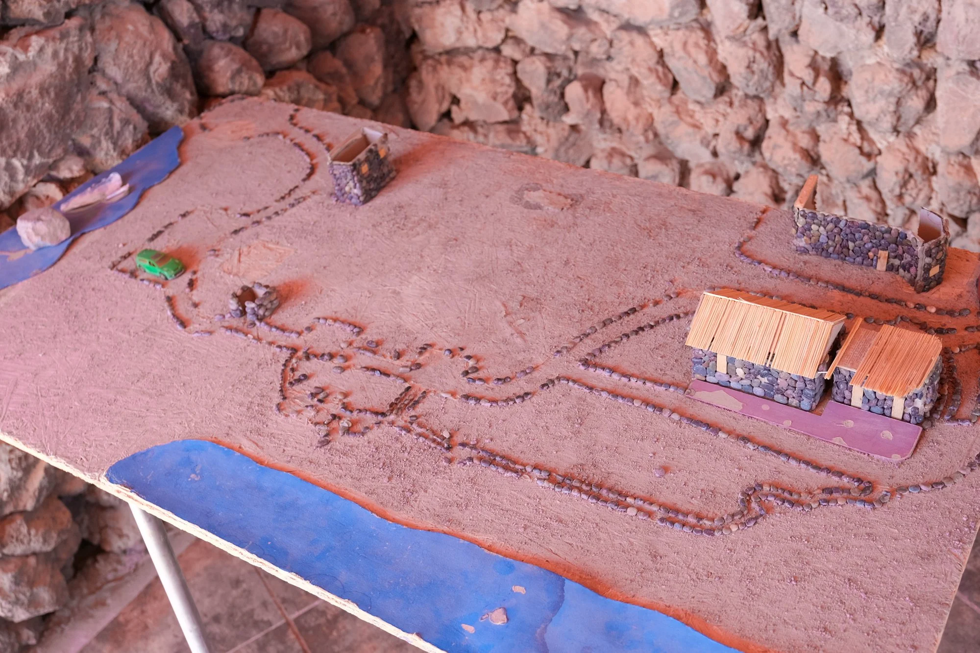
A handy model demonstrating the routes around Laguna Miscanti and Laguna Miñiques.

Laguna Miscanti.

Laguna Miscanti is surprisingly teeming with wildlife.
The marked tracks led visitors to several viewpoints along the shore. Aside from the beautiful scenery, visitors will be delighted by the abundance of wildlife hidden in plain sight. From the llama-like vicuñas to the ostrich-like Darwin's rhea, it was amazing that such a foreboding landscape could be teeming with life. I can’t believe we forgot to bring our binoculars on this trip. There are quite a few kilometers of walking trails around the lake. Unfortunately, we did not have the time to take in the serenity of this place. Am I wrong to secretly wish that there was a lovely cafe here? This would also bee a great place to camp overnight.

The beauty of Laguna Miscanti.
The second lagoon is just a quick five-minute drive away. The two lakes were once connected until the landslide created by the eruption of a nearby volcano—the mineral deposit between the two lakes functions as a natural filter for the water. As a result, Laguna Miñiques has a slightly different color to its water than its bigger sister. These lagoons are the significant breeding ground for horned coots, one of the eighteen species commonly sighted here. They nest along the shore, but the seagulls from the coastal region frequently snatch the chicks from the coastal areas.

Laguna Miñiques.

Laguna Miñiques.
Although I enjoyed the scenery, Brian was impatient, as the two lagoons looked similar, in all honesty. Because the access is strictly controlled and monitored, it was not easy to spend extended time here. That said, I could appreciate the care that has gone into preserving the pristine landscape. There may be many visitors, but the place still feels very secluded. We felt a world away from the bustle of San Pedro.
Piedras Rojas
None of Atacama’s high-altitude lakes is more iconic than Piedras Rojas, meaning “Red Rocks” in Spanish. The site is world-famous for its vibrant colors and alien-like landscape. It was a solid 45-minute drive from Laguna Miñiques. Thanksfully, Route 23 is well-maintained and a joy to travel on. The color rendition here is more vibrant than all the other salt lakes we have visited thus far. Even from afar, I was immediately mesmerized by the lake's pastel colors and mountain backdrops. Piedras Rojas is covered under the admission ticket we received at Socaire. Given the trouble we went through in getting these tickets, I was a little taken aback when the staff “confiscated” ours upon entry.

The trek to Piedras Rojas.
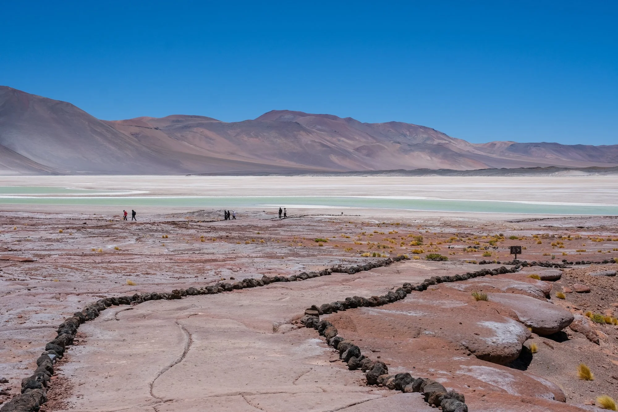
The trek to Piedras Rojas.

The otherworldly beauty of Piedras Rojas.
We were instructed to follow a well-marked trail for a one-way loop to the shore. The day's weather may be spectacular, but it was far from a pleasant walk. The gale-force winds were so intense that many of us struggled to walk in a straight line; it was even difficult for us to converse with one another. The harsh climatic condition was a sharp contrast to the beauty of the scenery. At more than 13,500 feet above sea level, we quickly felt the dizzying effects of the thinner air. I could tell that Brian was sluggish and miserable. He was in no mood for sightseeing, as it was a “breathtaking” experience in the literal sense.
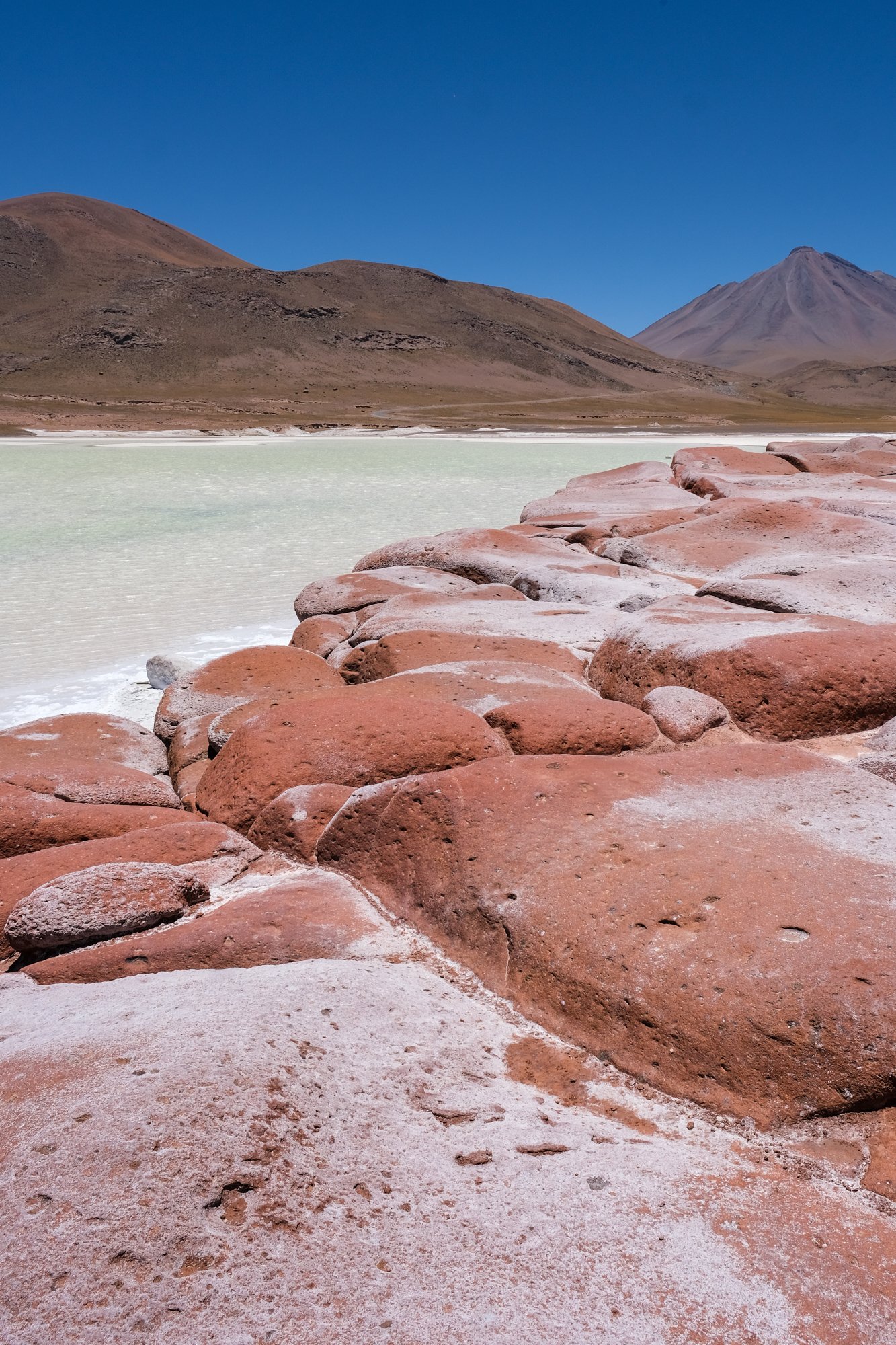
The famous red rocks of Piedras Rojas.

Piedras Rojas may look calm, but the gale-force winds were intense.
After about ten minutes, we finally arrived at the water’s edge. This particular section is filled with ruby red rocks and with rounded shapes. If you have seen some photographs of Piedras Rojas online, you might be disappointed by the color saturation in person. Photos can be easily manipulated nowadays; some travel blogs and tour operators often apply unrealistic filters to their photos. I found the subtle red hue in reality to be far more elegant and captivating. However, the real beauty is the mint-green lagoon on the horizon and the gray-washed mountains.

We were out of there right after the getting the “money shot.”
Because of its popularity, this is probably Chile’s most “Instagrammable” spot. That inevitably meant a lot of shenanigans and out-of-control behaviors. As a result, there were plenty of staff to enforce all the rules. These include a ban on drone photography and stepping onto the salt flat itself. As much as we hoped to linger for some photoshoots, the environment was too hostile. I was even worried that the wind could blow my tripod away. Don’t be fooled by the calmness portrayed in all the pictures of Piedras Rojas.
Laguna Tuyajto
When we finished visiting Piedras Rojas, Brian was thoroughly exhausted by the wind and the high altitude. It took some convincing on my part that we should see just one other salt lake. Laguna Tuyajto is an endorheic basin at the foot of Tuyajto volcano. At 13,238 feet, it is roughly the same elevation as Piedras Rojas, so I knew we should not linger for long. Even though it was only a quick 15-minute drive away, there was hardly anyone at Laguna Tuyajto. The color contrast between the saline deposit and the surrounding landscape was just as dramatic and beautiful.

Laguna Tuyajto.

Laguna Tuyajto.

Laguna Tuyajto.
The size of Laguna Tuyajto varies seasonally and is subjected to excessive evaporation. The lake was fed by an underground saline spring and has no outlet. Although it covers a quarter of an acre in surface area, the maximum depth is only about two feet, and I was tempted to get in. Unlike the other salt lakes we visited thus far, Laguna Tuyajto has no visible, sanctioned hiking trail beyond the parking lot. I have seen pictures of people driving off-road to the shore, but I couldn’t risk being arrested for trespassing.
The Argentinian border was only an hour away from this spot, and the governmental border checkpoint was forty minutes away. Judging from the traffic, this is far from a popular crossing. If alone, I might check out the border crossing for the novelty. Of course, driving across South America's borders is far from straightforward. It requires visa authorization, insurance, and permits from the rental car company. Let’s hope South America will soon have its version of Schengen to make the cross-border travel a breeze.

Laguna Tuyajto.

I had the pleasure of being the first to congratulate them for their engagement.
As we pulled into the lagoon’s small parking lot, there was just one other car. I spotted a gay couple on the nearby hill making out in public. Chile may be relatively LGBT friendly compared to Peru or Bolivia, but it is still a conservative Catholic nation. Brian and I never engaged in PDA, so seeing public same-sex affection in rural Chile threw us off a little bit. While taking a few photos, the couple tapped me on the shoulder and asked whether I could take a picture for them. It turned out the couple just got engaged on this spot! I was more than happy to be the impromptu engagement photographer and the first person to congratulate them. They certainly picked a memorable yet secluded spot for this tremendous occasion.